191 search results - page 36 / 39 » Image Based Localization in Urban Environments |
CJ
2010
13 years 5 months ago
2010
Sensor networks face a number of challenges when deployed in unpredictable environments under dynamic, quickly changeable demands, and when shared by many partners, which is often...
IROS
2009
IEEE
14 years 2 months ago
2009
IEEE
Abstract— Mobile robots rely on their ability of scene recognition to build a topological map of the environment and perform location-related tasks. In this paper, we describe a ...
3DIM
1997
IEEE
14 years 2 days ago
1997
IEEE
Geometric fusion of multiple sets of overlapping surface measurements is an important problem for complete 3D object or environment modelling. Fusion based on a discrete implicit ...
MICCAI
2009
Springer
14 years 2 months ago
2009
Springer
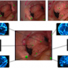
The quest for providing tissue characterization and functional mapping
during minimally invasive surgery (MIS) has motivated the development
of new surgical tools that extend the...
IROS
2006
IEEE
14 years 1 months ago
2006
IEEE
— Scan-matching based on data from a laser scanner is frequently used for mapping and localization. This paper presents an scan-matching approach based instead on visual informat...

