INFOVIS
2000
IEEE
14 years 3 months ago
2000
IEEE
Most work with geospatial data, whether for scientific analysis, urban and environmental planning, or business decision making is carried out by groups. In contrast, geographic vi...
INFOVIS
2000
IEEE
14 years 3 months ago
2000
IEEE
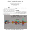
ThemeRiver™ is a prototype system that visualizes thematic variations over time within a large collection of documents. The “river” flows from left to right through time, ch...
INFOVIS
2000
IEEE
14 years 3 months ago
2000
IEEE
COMIND is a tool for conceptual design of industrial products. It helps designers define and evaluate the initial design space by using search algorithms to generate sets of feasi...
INFOVIS
2000
IEEE
14 years 3 months ago
2000
IEEE
We describe MGV, an integrated visualization and exploration system for massive multi-digraph navigation. MGV’s only assumption is that the vertex set of the underlying digraph ...
INFOVIS
2000
IEEE
14 years 3 months ago
2000
IEEE
Lighthouse is an on-line interface for a Web-based information retrieval system. It accepts queries from a user, collects the retrieved documents from the search engine, organizes...


