Free Online Productivity Tools
i2Speak
i2Symbol
i2OCR
iTex2Img
iWeb2Print
iWeb2Shot
i2Type
iPdf2Split
iPdf2Merge
i2Bopomofo
i2Arabic
i2Style
i2Image
i2PDF
iLatex2Rtf
Sci2ools
128
click to vote
ICCV
2009
IEEE
2009
IEEE
Shape-based Recognition of 3D Point Clouds in Urban Environments
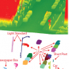
This paper investigates the design of a system for recognizing
objects in 3D point clouds of urban environments.
The system is decomposed into four steps: locating, segmenting,
characterizing, and classifying clusters of 3D
points. Specifically, we first cluster nearby points to form
a set of potential object locations (with hierarchical clustering).
Then, we segment points near those locations into
foreground and background sets (with a graph-cut algorithm).
Next, we build a feature vector for each point cluster
(based on both its shape and its context). Finally, we label
the feature vectors using a classifier trained on a set of manually
labeled objects. The paper presents several alternative
methods for each step. We quantitatively evaluate the
system and tradeoffs of different alternatives in a truthed
part of a scan of Ottawa that contains approximately 100
million points and 1000 objects of interest. Then, we use
this truth data as a training set to recognize obje...
Related Content
| Added | 13 Jul 2009 |
| Updated | 10 Jan 2010 |
| Type | Conference |
| Year | 2009 |
| Where | ICCV |
| Authors | Aleksey Golovinskiy, Vladimir G. Kim, Thomas Funkhouser |
Comments (0)

